test
Route of the Walls
Route of the Walls
If there is an urban feature that distinguishes Tortosa from other municipalities in Catalonia, it is the defensive heritage that is still preserved, despite the significant changes made since the end of the 19th century, when the city walls began to be demolished to allow urban growth and improve road circulation.
Although the military history of the city dates back to Late Roman times (with the Late Antique wall, which can be visited at the Cota Zero space), this route mainly aims to present the entire outer circuit of walls and bastions dating from the Late Middle Ages to the 19th century. The route can be followed in the indicated direction or in reverse.
1. Tenasses Fortification
Located at the northern end of the city on an isolated hill, completely separated from the urban centre by the Célio ravine.
From an initial hornwork built during the Reapers’ War, after Tortosa fell into Bourbon hands in 1708, the new military authorities decided to reinforce the northern flank of the walls, which had been heavily affected by the siege of the Duke of Orleans.
The complex consists of two adjoining defensive structures with different functions. The first, closer to the city, contains two rooms that served as a powder magazine and a water cistern. The courtyard acts as a distributor from which the rooms are accessed and also provides access to the upper part of the bastion, equipped with eighteen cannon embrasures.
The second is a large enclosure located beyond the moat of the first section. It includes an area known as the parade ground, located on the northern plateau. The northern front contains a fortification with two semi-bastions joined by a central curtain wall forming the hornwork, preceded by a moat with a ravelin and a covered path paved with cobblestones, which has been restored.
2. Remolins Gate
Unfortunately, in this case we can only speak in the past because this access point to the city from the north disappeared more than a century ago due to urban planning changes that removed the old city gates, which made the passage of wheeled vehicles difficult. Historical drawings show that it consisted of two square towers framing a gate with a semicircular arch.
3. Célio Tower, medieval wall section and Jews’ Gate
This sector of the walls preserves one of the best examples of the original 14th-century structure, when the defensive circuit of Tortosa was built during the War of the Two Peters.
At the northern end stands the Torrassa or Célio Tower, circular in plan and still in good condition compared with the drawing by Anton van den Wijngaerde from 1566, in which it had already lost its roof.
The upper walkway between this tower and the Prince’s Gardens is fully accessible to visitors, as the entrance to the upper circuit is located there.
An important point in this sector is the Jews’ Gate, originally called the Iron Gate because its doors were reinforced with iron plates. Although partially buried, it remains intact and allowed access from the Jewish quarter to the community’s necropolis located outside the walls.
4. San Juan Outworks
This complex consists of several defensive enclosures built during the 17th and 18th centuries. The result is a complex defensive structure about 300 metres long, located on the hill closest to the Suda as a continuation of the fortifications.
The first area, closest to the Suda Castle, has the oldest walls. Much of the area is now occupied by roads that allow vehicles to reach the castle summit.
The second enclosure begins with a moat at the base of the medieval wall. The entrance gate has a semicircular arch. Next comes the hornwork, formed by two lateral semi-bastions connected by an elongated central structure.
Finally, the third sector features a central parade ground with outer walls or barbacans on the flanks and an irregular bastion protected by a moat, ravelin, covered path and glacis.
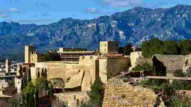
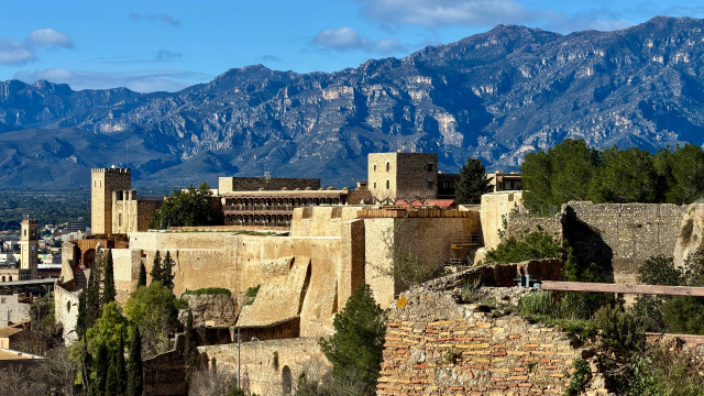
5. Suda Castle
Without any doubt, this is the most important defensive complex in Tortosa. The city was founded on the top of this hill and it has witnessed the passage of many peoples and civilizations since antiquity.
Much of the upper area is occupied by the Parador de Turismo, but several notable elements can still be visited: an Andalusi necropolis, underground chambers around the deep central well, and several cannon embrasures offering spectacular views of the city and the surrounding landscape.
6. Bonet Fort
This name comes from the shape of the fortification, which resembles a type of ecclesiastical hat. Built between the 17th and 18th centuries, it consists mainly of a single bastion surrounded by a narrow moat.
7. Rastre Wall
This is the most monumental preserved section of the medieval walls. It has been restored to allow visitors to walk along the upper passage and connects the Rastre square with the Sitjar hill.
8. Tarragona Gate
This is the most majestic surviving medieval gate of the city walls. Documentation suggests that it began to be built in the mid-14th century.
9. Sitjar Hill Fortifications
These bastions, together with the San Juan outworks, form the defensive complex designed by military engineers in the second half of the 17th century to protect the western flank of the city.
10. Orleans Fort
This is the southernmost fortification of the wall circuit. It was built after the War of the Spanish Succession and takes its name from the Duke of Orleans, who conquered Tortosa in 1708.